← Everything Everywhere Daily: History, Science, Geography & More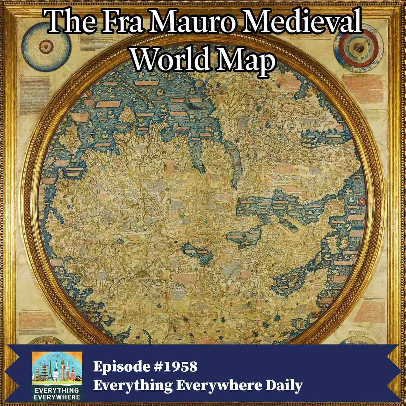
Everything Everywhere Daily: History, Science, Geography & More
The Fra Mauro Medieval World Map
00:14:34
Loading summary
Transcript1 lines
- [00:01]
A
Sometime around the year 1450, a monk living just outside of Venice created one of the greatest maps of the medieval world. It was an enormous map, even by modern standards, and had a level of detail that had never been seen before. It took years to make and was a major advancement in cartography, but perhaps most importantly, it contained many details that no one had yet verified firsthand, opening the door to the age of exploration. Learn more about the Fra Maro map, how it was created, and its significance on this episode of Everything Everywhere Daily. This episode is sponsored by Quint's the holiday season is upon us and that means buying gifts for friends and family. So why not get something that's top tier but affordable? That's where Quince comes in. Quince has great items like $50 Mongolian cashmere sweaters that feel like an everyday luxury and wool coats that are equal part stylish and durable. And you'll pay a fraction of what you would from other retailers. And their prices are literally listed on the Quince website. I just got an Australian merino wool sweater that looks great and cost only half of what it would have in if I had bought it somewhere else. By partnering directly with ethical factories and top artisans, Quince cuts out the middleman to deliver premium quality at half the cost of similar brands and often even bigger discounts. Give and get timeless quality staples that last this season with Quince. Go to quints.com daily for free shipping on your order and 365 day returns. Now available in Canada too. That's Q U-I-N-E.com daily free shipping and 365 day returns. Quince.com daily this episode is sponsored by Mint Mobile. The reality is that smartphones and their associated mobile plans have become an indispensable part of the modern world. You almost can't get by without one. So if you have to have a monthly plan, why spend any more than than you need to? That's why I recommend Mint Mobile. All their plans come with high speed data and unlimited talk and text delivered on the nation's largest 5G network. You can use your current phone, current phone number and keep all of your current contacts. Nothing has to change except the amount you pay. At Mint Mobile their favorite word is no. No contracts, no monthly bills, no overages, no hidden fees and no bs. Ready to say yes to saying no? Make the switch@mintmobile.comeed that's mintmobile.comeed upfront payment of $45 required, equivalent to $15 a month limited time. New customer offer for first 3 months only. Speeds may slow above 35gb on unlimited plan taxes and fees extra. See Mint Mobile for details. Before I start, let me clarify for the purpose of this episode, I'm calling the events that I'll be covering the late medieval period. Some people call the Fra Maro map a Renaissance work, but I'm going to be calling it a medieval work for reasons that will become obvious. It was created at the borderline period between the end of the medieval and the start of the Renaissance, and that transition isn't really cut and dry. So with that, it's first necessary to understand the roles that maps played in medieval Europe. In the medieval world, cartographers were not trying to do what we expect maps to do today. For most of the period, especially in Latin Christendom, the main world maps, or mappamundi, were visual encyclopedias and theological diagrams rather than tools for precise navigation or measurement. They were organized around salvation history and biblical geography, so they always placed Jerusalem at the center of the map, the Garden of Eden at the top, and then arranged the three continents according to the sons of Noah, even when this distorted their actual shape and size. This emphasis on theology made it hard to incorporate new empirical information without disrupting the theological structure, and it meant that accuracy in distance orientation or coastline shape was often a secondary consideration. In addition to theology, there were also major conceptual and mathematical limits. Medieval mapmakers were aware of classical sources that described the Earth as a sphere, but they lacked a theory of map projections to translate a curved surface onto a FL sheet. The Mercator projection, which I covered in a previous episode, wouldn't be developed for over a century. For many charts, the Earth was treated as effectively flat, and distances and bearings were simply plotted on a flat plane, which worked OK for short ranges but introduced growing distortions over larger ones. Without a systematic projection, there was no controlled way to manage trade offs between shape, area, and direction, so scales wandered across the page. Parallels and meridians were inconsistent, and different regions sitting side by side on the same map might be based on incompatible geometric assumptions. Measurement technology imposed another set of constraints. Latitude could be measured roughly from the height of the pole star or the length of the day, but the resulting values were often off by a degree or more. Longitude was effectively impossible to determine at sea before the advent of accurate timekeeping, which was still several centuries away. Lastly, information about many regions was thin, patchy, or mediated through texts rather than surveys. For the Mediterranean and Black Seas, sailors gradually produced remarkably accurate charts whose coastlines agree closely with modern maps, likely compiled from accumulated bearings and distances sailed outside of these intensely traveled waters. However, knowledge declined rapidly. So with that background, the story really begins in Venice in the mid 15th century. Venice at this point was one of the great clearinghouses of global information. A maritime republic that handled trade between the Mediterranean, the Black Sea, and, via caravan routes and Islamic intermediaries, the distant markets of India and China. If one wanted to know about the rest of the world, or at least what could be known of it, at this time, there was no better place to be than Venice. Merchants and sailors who traveled throughout Europe, the Near east and parts of Africa all came to Venice, and it was here that a monk, known to us only as Fra Mauro lived and worked. Fra maro was a 15th century Venetian cambadlese monk and a cartographer who lived and worked in the monastery of San Michel on the island of Murano, which today is known for its famous glasswork. Born probably in the late 1300s, he had been a lay brother involved in commerce and travel, before entering a manasseh domestic life, which allowed him to travel widely and gave him an unusual grasp of the world's trade networks. Later in life, he lived at the monastery and became a full monk, and among his duties, he was a cartographer. The monastery had become an essential center for mapmaking by the mid 15th century, given its strategic position in Venice. The reason I am doing an episode on this topic has to do with a request from King Alfonso Voice of Portugal. At some point in the mid to late 1440s, Alfonso requested a map that provided the most accurate representation of the known world. Portugal was at the forefront of maritime exploration during this period, and Portuguese sailors were gradually pushing down the West African coast, seeking routes to the wealthy markets of Asia and hoping to bypass the Ottoman controlled eastern Mediterranean trade routes. It's essential to note that this occurred very early in the period that would later become known as the Age of Exploration. No one had yet sailed around Africa to India, and no Europeans had sailed to the Americas. All of the information that would come from these voyages had yet to be discovered. And this is why I consider it to be late medieval rather than early Renaissance, at least in terms of cartography. Frau Mauro worked on the map for over a decade. Records show that the map was completed on April 24, 1459. What he and his assistant, the Venetian pilot and cartographer Andrea Bianco, created was the most revolutionary map in history at that point. What makes the Frau Maro map revolutionary for its time is its departure from the theological cartography that dominated medieval European mapmaking. Unlike the maps common in medieval Europe, which placed Jerusalem at the center and organized geography according to biblical interpretation, Frao Mauro's map attempted to represent the world based on empirical knowledge gathered from travelers, merchants, and explorers. The map is oriented with the south at the top of the map, a convention common in Islamic and some European nautical charts of the period. Although it may seem unusual to modern viewers accustomed to north oriented maps, the map sources were extraordinarily diverse for its time. Frau Maro drew upon the works of Ptolemy, the ancient Greek geographer whose book Geography had recently been reintroduced to Western Europe through Byzantine and Arabic sources. However, Fra Mauro was not slavishly devoted to Ptolemaic geography and was willing to correct or reject Ptolemy's assertions when they conflicted with more recent information. He incorporated knowledge from Marco Polo's travels to China in the late 13th century as well as accounts from Niccolo di Conti, a Venetian merchant who had traveled extensively in Asia and the Indian Ocean in the early 15th century and whose reports provided relatively recent information about those distant regions. Islamic geographic knowledge played a crucial role in shaping the map as well. Through Venice's extensive trading relationships and the availability of Arabic sources, Frau Mauro had access to sophisticated Islamic cartography and geographic texts that contained information from far superior to contemporary European knowledge about Africa, Asia, and the Indian Ocean. The map reflects this Islamic influence in its detailed depiction of the Indian Ocean, its relatively accurate representation of the African coastline, and its inclusion of numerous Asian place names and geographic features. The physical execution of the map itself is also remarkable. It was drawn on parchment, mounted on wooden panels, and features thousands of inscriptions in Venetian dialect providing descriptions of regions, cities, people, and phenomenon from around the world. The map is a square, approximately 2 meters or 6ft on each side. These inscriptions are not merely labels, but often contain extended commentary reflecting Frau Mauro's critical engagement with the sources. The map is richly illuminated with miniature illustrations depicting cities, ships, animals, rulers, and various scenes of human activity, making it not only a geographic document but also a Visual Encyclopedia of Mid 15th Century Knowledge of the world. One of the map's most significant features is its representation of Africa. Unlike earlier European maps that often depicted Africa as a relatively small landmass or left its southern extent unknown, the Fra Mauro map shows Africa as a large continent that could potentially be circumnavigated. The map includes an inscription suggesting that a Chinese junk had sailed around the Cape of Good Hope from the Indian Ocean into the Atlantic, demonstrating that such A voyage was possible. While the accuracy of this claim remains debated amongst historians, it reflects the contemporary interest in finding a sea route to Asia around Africa, a quest that would culminate in Bartolomo Diaz's actual rounding of the cape in 1488. The map's depiction of Asia is extensive and detailed, showing not only the near east and India, but but also extending to China and Southeast Asia. Frau Mauro included information about the Mongol Empire, though by his time it had already fragmented and depicted various Asian kingdoms and peoples. The representation of the Indian Ocean is particularly sophisticated, showing it as an open sea connected to the Atlantic, rather than as an enclosed body of water, as Ptolemy had suggested. This correction of Ptolemaic geography had enormous implications for the age of exploration that was just beginning. In depicting Europe, Frao Mauro naturally had access to the most detailed and accurate information, and the continent is represented with considerable precision for this period. The Mediterranean region, which was the center of Venetian commercial interests, receives particularly detailed treatment. The map also shows parts of northern Europe, including Scandinavia, although with less detail and accuracy than the southern regions. The inscriptions on the map reveal Frau Mauro's methodology and his awareness of the limitations of his knowledge. He frequently cites his sources, acknowledges uncertainties, and notes where different accounts conflict. This scholarly approach distinguishes his work from many earlier maps and demonstrates a proto scientific attitude towards geographic knowledge. He was particularly interested in recent discoveries and contemporary reports showing that he conceived of geography as an evolving field of knowledge rather than a fixed body of inherited wisdom. If you look at the Fra Mauro map, your initial reaction might be that it isn't a very good map, but you have to grade it on a curve. Yes, it doesn't look like a modern map, but if you zoom in on particular parts of the map, it isn't that bad, especially given all the limitations of cartography that I listed at the start of the episode. The original map created for the Portuguese king is believed to have been lost, possibly in a fire or an earthquake. However, Fra Maro created a second version for the Signoria of Venice, and this is the map that survives. Today it's housed in the Bibliotheca Nacional Marchana in Venice. The map suffered damage over time, including water damage and deterioration of the parchment and pigments. However, conservation work has helped preserve this invaluable historical document for future generations. In honor of his work, there is a crater on the moon named after Fra Maro, and the Frao Mauro highlands became the landing site for Apollo 14. The Frao Mauro map wasn't just a landmark in cartography. While we don't have any direct proof, it's reasonable to assume that the map commissioned by King Alfonso of Portugal played a role in the continued support for voyages to seek a route to Asia that sailed around Africa, which was eventually done by Portuguese explorers. Likewise, because it showed the Indian and Atlantic oceans being connected, it may have planted the seed for explorers to sail west in an attempt to reach Asia, which ultimately led to the discovery of the New World. As such, the Fra Mauro world map is more than just a monument of medieval European cartography. It's a work that, in a very real sense, may have changed the course of history. The executive producer of Everything Everywhere Daily is Charles Daniel. The associate producers are Austin Otkin and Cameron Kiefer. My big thanks go to everyone who supports the show over on Patreon. Your support helps make this podcast possible, and I also want to remind everyone about the community groups on Facebook and Discord. That's where everything happens that's outside the podcast, and links to those are available in the show Notes. As always, if you leave a review on any major podcast app or in the above community groups, you too can have it read on the show.