← Short Wave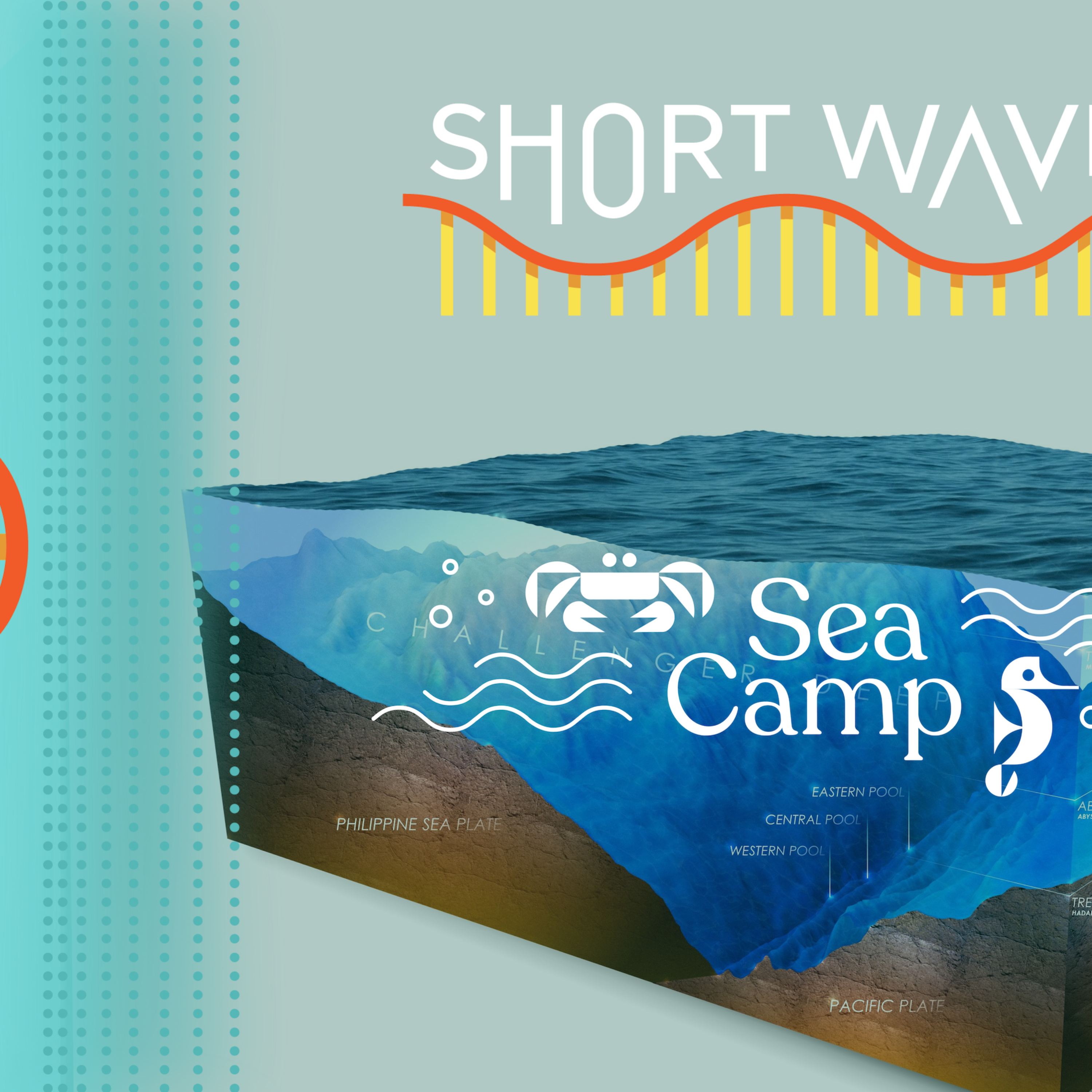
Short Wave
Why mapping the entire seafloor is a daunting task, but key to improving human life
00:14:05
Loading summary
Transcript45 lines
- [00:00]
A
This message comes from NPR sponsor Lucasfilm presenting Andor Season 2. Andor has earned 14 Emmy nominations, including writing, directing and outstanding drama series. Vanity Fair raves that Andor is profoundly resonant. It's the best television of the year. All episodes of Andor are now streaming on Disney.
- [00:22]
B
You're listening to Short Wave from npr. Hey, short wavers. Emily Kwong here and Regina Barber back with our next installment of our summer sea camp series. I love this series. It's been so fun. It has been. Where are we going today? Rock bottom, Emily. Rock bottom. Oh, we're in the Hadal zone, the.
- [00:46]
C
Deepest zone that we are aware of. People also refer to it as the Trenches, and there aren't a lot of these places in the oceans.
- [00:56]
B
That's Noelle Bolen. She's our go to marine biologist from the national oceanic and Atmospheric Administration. And she says the Hadal zone is any area 6,000 meters below sea level and deeper. How deep does it go? Yeah, the depths of the trenches can vary, but the deepest one, the Mariana trench, is almost 11,000 meters, or nearly seven miles deep. That's very far. I've heard of the Mariana Trench, but now that I imagine my seven mile run downwards, that's quite deep. Yeah, I do not think I ever run that far, but I want to. It makes sense that this is a really tough place to study, let alone get humans down there. But we're going down there today? Yes. By hearing from Dawn Wright, one of less than 30 people who visited the deepest point in the Mariana Trench, a place known as Challenger Deep. Let's go.
- [01:49]
D
Descending in a submersible is not unlike being in a space capsule in many ways. You're in a very small space, not enough room to stand up. It was very slow and very peaceful and very calm. And as we got to around 800 to 900 meters depth, that's when we lost light. We were treated to a fireworks show of sorts. Worms, jellyfish, anglerfish. They used bioluminescence to communicate with each other.
- [02:26]
B
Don's traveling companion, pilot Victor, started flashing the lights of their submersible and we.
- [02:34]
D
Saw them flash back.
- [02:37]
B
But don didn't travel 10,000 meters or 6.7 miles underwater just for a light show. Don is a marine geographer.
- [02:45]
D
I study the rocks and the motion at the bottom of the ocean so that we have a better idea of how the Earth works at the bottom of the sea.
- [02:58]
B
On this particular mission, dawn was testing a new sonar device that operates at extreme depths and pressures with the goal of creating a detailed map of the seafloor, which is important to know because the geologic activity on the seabed is.
- [03:12]
D
The most exciting, the most perplexing, and the most important.
- [03:17]
B
Most important because it's where underwater earthquakes start, which can lead to tsunamis. Understanding the seafloor helps scientists and policymakers keep people saf. And that's one reason Don and many other scientists are involved in a global effort led by the Nippon foundation and GEBCO called Seabed 2030.
- [03:35]
D
The goal of Seabed 2030 is to give us a detailed modern map of 70% of the planet that we have known very, very little about.
- [03:48]
B
Today on the show, cataloging the unknown why knowing more about the farthest reaches of the ocean floor is important for life here on land, from tsunami safety to renewable energy and even the Internet. I'm Regina Barber and you're listening to Shortwave, the science podcast from npr.
- [04:16]
C
Support for this podcast and the following message come from Strawberry Me. Be honest. Are you happy with your job? Are you stuck in a job you've outgrown or never wanted in the first place? Are your reasons for staying really just excuses for not leaving? Let a career coach from Strawberry Me help you get unstuck. Discover the benefits of having a dedicated career coach in your corner and claim a special offer at Strawberry Me NPR. This message comes from NPR's sponsor, Thrive Market. It's back to school season, aka snack packing, lunch making, schedule juggling season. Thrive Market's back to school sale is a great way to stock up this month with 25% off family favorites easily filter by allergy or lifestyle. To find kid approved snack packs, organic dinner staples and more, all delivered to your door. Go to thrivemarket.com podcast for 30% off your first order and a free $60 gift.
- [05:13]
A
This message comes from Square. Your favorite neighborhood spots are using SQUARE to do everything from covering cash flow gaps to expanding to new locations. Wherever your business is growing, Square meets you there. Go to square.com go NPR to learn more.
- [05:32]
B
Okay dawn, just to start, how does one map the seafloor?
- [05:36]
D
It works through sonar, sound, navigation and ranging. And this is because sound is the most effective way of sensing the undersea environment. So the basic principle is to send pulses of sound from an instrument or a ship down to the ocean floor. We can time the amount of time that it takes for the pulse to reach the ocean floor and come back to the instrument and that time is turned into a distance. So that is where we get our depths. And then we have all kinds of sophisticated algorithms for making sure that we're getting the proper time because the speed of sound changes according to the temperature and the salinity of the the water which varies throughout the oceans.
- [06:21]
B
Yeah, of course. Okay, so from what I understand sonar of the seafloor, that's what let scientists in the 60s put words to how formation happened. Right. Like things like ridges, trenches and even like the Ring of Fire, the most seismically and volcanically active area of the world, where the Pacific tectonic plate meets the other tectonic plates where I used to live. So the seismic activity, that's a big reason for mapping the ocean floor, right?
- [06:50]
D
Yes. Mapping the ocean revealed all of those features. It revealed the large chains of volcanoes which are known as the mid ocean ridge. In fact, it was the work of Marie Tharp in particular, she mapped all of the world's oceans and those mid ocean ridges, those large trenches where a lot of the earthquakes occur. And also the very large scars on the sea floor that are known as fracture zones. These are places where seafloor is sliding past each other. So this is like the San Andreas fault underwater. So these are all of the big major tectonic features that popped out in beautiful glorious detail and revealed themselves once we started getting these maps of the.
- [07:48]
B
Ocean floor and those features, they can also lead to things like tsunamis.
- [07:54]
D
Yes. So tsunami comes about as a result of a movement on the floor of the ocean that's expressed in a fault. When you have that disruption on the ocean floor, the water above the ocean floor gets severely disrupted as well and generates these large long wavelength waves that are essentially the tsunamis. We can make sure that we are monitoring those areas. But even more importantly, we must understand what the bathymetry is there.
- [08:34]
B
Okay. And what's bathymetry?
- [08:36]
D
If people understand topography on land, which is how elevation changes over certain distances, that's what bathymetry is on the sea floor. So it's under sea topography. In your old home of Washington and certainly in Oregon, there is a Cascadia subduction zone that is not far off the coast of Oregon and Washington that can generate these types of tsunamis. And the warning time will be very, very short. So if we understand what the bottom of the sea floor looks like in those coastal areas, that helps us to plan more effectively for where people should evacuate or how they should evacuate, what roads should they take, what roads they should avoid, how to get to higher land as quickly as possible. Right, so that's one of about 50 reasons why we should map the ocean floor.
- [09:31]
B
And what are some of those reasons?
- [09:32]
D
Another very, very Important reason is we are looking to the ocean now for energy, more wave energy, for instance, or wind energy. And we are siting wind turbines on the ocean floor. So we need to know what the ocean floor looks like, which areas are flat, for instance, and also what the composition of those areas is. Is it sandy? Is it silty, Is it rocky? What are the best places for us to anchor that type of alternative energy infrastructure? That's a huge use of ocean mapping. One more is for habitat. We enjoy fish and other types of protein from the ocean.
- [10:24]
B
Right.
- [10:24]
D
A lot of it is near or on the ocean floor. And in order to monitor and to protect the habitat of those fisheries, that's a huge use for seafloor mapping. We need to have the seabed mapped for all kinds of different purposes, one of which is the whole idea of Internet traffic.
- [10:52]
B
Right. Because so much of our Internet connections actually go through these cables that are, like, on the sea floor, these submarine cables. And your company, esri, actually deals with some of those maps.
- [11:05]
D
Exactly. Yeah. At our company, we deal with anything that can be mapped. We have a beautiful animated map of all of the world's submarine cables that help people to understand all of this infrastructure, all of these processes. And our maps show that 99% of all of our Internet traffic is carried by these submarine cables. So modern life, everything from podcast to Pokemon go account to WhatsApp group to all of the streaming videos. I'm thankful for my BritBox subscription so I can get my British murder mysteries.
- [11:49]
B
Yes.
- [11:50]
D
I'm thankful to the ocean floor for that.
- [11:52]
B
Yeah. And this all leads us to the Nippon Foundation GEBCO Project Seabed 2030. And you're part of this strategic advisory group for this effort to map the entire seafloor by 2030. And as of June 2025, you're at 27.3%. How is this going?
- [12:11]
D
So we have a long way to go, but we have also come up from around 6% just in the last few years. We're also working with various industries that have bathymetry data that they have not released yet. And the hope is that we can very quickly get to 40% if we can get a lot of these companies to release their data and to make it public. We're hoping to get very close by 2030. But the work, all of this work, is going to continue beyond 2030, for sure.
- [12:48]
B
Yeah. And I know one of the nonprofits involved in this effort is Map the Gaps, which is focused on making sure data is open access and that there's increased equity and awareness of seafloor mapping and the whole process. And part of this means getting anyone with like a boat to help map the seafloor as they're out and about, which I think is really cool.
- [13:09]
D
Yes, yes, that's part of it too. In fact, there's the expression cheap and deep where you don't have to have a huge sophisticated research vessel or a $20 million robot to map the ocean floor. Everybody can contribute.
- [13:24]
B
What if the seafloor isn't totally mapped 30, 40, 50 years from now? What are the consequences of not mapping that seafloor?
- [13:34]
D
We are going to be putting our public safety at risk by not having the proper understanding of not only tsunami run up, but storm run up along our coasts. We are going to be running the consequences of not fully understanding sea level rise and shoreline change. We could be losing valuable fisheries forever. We are going to have a hard time with the security of our ports. If we do have additional accidents or emergencies at sea, how are we going to find things we still have not found? MH370, that airplane that was lost.
- [14:21]
B
Oh geez.
- [14:22]
D
There was never going to be a very quick way to find or to rescue the Ocean Gate Titan submersible. And those are just two individual examples. So all of these areas, all of these reasons for mapping the ocean floor, the longer that it takes us to get to close to 100%, we are just going to be playing with fire, so to speak.
- [14:50]
B
Dawn, thank you so much for talking to us about mapping the seafloor.
- [14:54]
D
Oh, thank you so much. I really enjoyed this.
- [15:01]
B
Before we head out, I want to encourage you to sign up for our Sea Camp newsletter where we go deeper with all the cool science we learn each week. There's extra research, animals, comics, even fun games. Sign up@npr.org secamp this episode was produced by Burleigh McCoy and edited by our showrunner, Rebecca Ramirez. Rebecca and Anil Oza checked the facts originally. Burleigh checked the CCAMP version of this episode. Robert Rodriguez was the audio engineer. I'm Regina Barber. Thank you for listening to Short Wave from npr.
- [15:43]
A
This message comes from NPR sponsor Shopify, the commerce platform behind millions of businesses around the world and 10% of all E commerce in the US get started with your own design studio. Sign up for your $1 per month trial@shopify.com NPR this message comes from Capital One. With the Spark Cash plus card, you earn unlimited 2% cash back on every purchase for your business. Find out more@Capital1.com SparkCashPlus terms apply.
- [16:14]
C
This message comes from Ollie dedicated to helping you prioritize your wellness with solutions that fit seamlessly into your routine. Ollie knows that keeping your immune system healthy is key, which is why they offer Women's Multi and Probiotic Mango. And for those occasional nights when sleep is hard to find, Ollie's Sleep Gummies are available. Shop these products and more at ollie. Com or retailers nationwide. These statements have not been evaluated by the Food and Drug Administration. These products are not intended to diagnose, treat, cure, or prevent any disease.